-
Model:
ADMT-200AX, ADMT-500AX
-
Features:
Auto 2D/3D Imaging. Options for depth selection and choices between MN and TT measurement modes. Data operation across the main device, smartphones, and PCs with a single account login, and data sharing among multiple accounts
Main Applications:
Groundwater Exploration: Finds ground water with better detail and accuracy than standard detectors, offering more features.
Mineral Exploration: Uses electromagnetic methods to map ore bodies and estimate mineral reserves in mining areas.
Single-Channel Professional MT Ground Water Detector
R&D Since 1973

6-Month Trade-Up Guarantee
The ADMT series products from AIDU utilize the natural electromagnetic field of the Earth as the source. Based on the principle that electromagnetic waves of different frequencies have varying skin depths in conductive media, these products measure the response sequence of electromagnetic signals from high frequency to low frequency at the surface. This process allows for the understanding of the electrical differences in geological bodies at various depths, thereby determining the occurrence state of the underground geological formations.
This professional water exploration product simplifies the Magnetotelluric (MT) method by enabling time-divided measurements of the natural electric field or electromagnetic field, facilitating the inversion of resistivity changes in different geological bodies underground. With a combination of portability, efficiency, precision, intelligence, and advanced Internet of Things (IoT) applications, these products are favored by both new and existing users.


Real-time
Imaging

Accurate
& Stable

Multi-screen
InterComm

Smart
& Versatile
MEET YOUR VARIOUS NEEDS

Groundwater Exploration

Mineral Exploration
Groundwater Exploration: Used for detecting underground water resources, offering finer slicing and higher precision compared to basic ground water detector, along with more comprehensive functionalities
Mineral Exploration: Extensively used for both reconnaissance and detailed surveys of metallic and non-metallic mineral deposits. Reduces investment risks and enhances mining success rates and scientific rigor.
Customer Cases

The Gold Mine Exploration in Myanmar

Product: High-Density MT Electromagnetic detector
Image Interpretation & Drilling Result: This gold mining site is located in Mawchi Myanmar, where the local gold deposits are classified as quartz vein-type gold. In measurement images, the quartz veins typically appear as red high-resistivity zones. The red high-resistivity areas in the measurement images are intermittent, reflecting the actual distribution of gold veins in the region, which also exhibits poor continuity—some sections are rich in gold while others are not. The geological profile represented in the images aligns well with the actual mining results.
SEVEN ADVANTAGES
TO HELP YOU EXPLORE WORRY-FREE
High precision and strong anti-interference
 The core module of the instrument adopts integrated packaging, which has high precision and greatly enhanced anti-interference. It is equipped with a high-performance processor to run a variety of algorithms, and the output is stable and accurate, ensuring the accuracy of the instrument in various environments
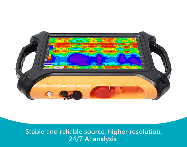
Auto Imaging
 Intuitive touchscreen operation—master it in 5 minutes. Get instant geological images with selectable 2D/3D color maps and various curve graphs after each measurement. Enjoy a seamless user experience
Adjustable Depth, Smart and Flexible
 Options for depth selection and choices between MN and TT measurement modes
Multi-Device Data Sharing
 Data operation across the main device, smartphones, and PCs with a single account login, and data sharing among multiple accounts
AI Automatic Analysis
 This device offers 24/7 free online AI-powered analysis of geological images. The AI system continuously learns and adapts from user feedback, enhancing its accuracy over time. This ensures increasingly precise guidance for water exploration and drilling, providing users with dependable and efficient support
Free App Upgrades,6-Month Trade-up
 Enjoy free online upgrades for the included app suite. Plus, exchange your product for a different model at no extra cost within 6 months of your purchase.
Lifetime Technical Support
 Comprehensive after-sales services, including data processing analysis, equipment maintenance, and online technical guidance, are provided as lifetime technical support
GOOD AT CORE AND BEAUTIFUL IN SHAPE

① Hi-Fi Signal Conditioning Amplifier Guaranteed signal accuracy
The analog circuit part of the front-end signal conditioning amplifier of the instrument adopts integrated packaging and shielding, which greatly enhances anti-interference, improves the signal input accuracy, and greatly improves the measurement accuracy of the instrument.
② High performance processor Run multiple algorithms
Adopt high-performance processor, run various algorithms, make the output stable and accurate, and ensure the measurement accuracy of the instrument
③ 7 inch touch screen operation
Real-time 2D/3D and curved images

① Handles ② Power Button ③ Charging Port ④ Multi-function Data Port
Accessories

① Electrodes
② Wired connection probe (optional)
Capable of operating on various terrains, including concrete, rock, and frozen soil. It can be operated by a single person.
③ Wireless connection golden rod (optional)
Fully wireless. Capable of operating on various terrains, including concrete, rock, and frozen soil. It can be operated by a single person.
Product design, packaging, or accessories are subject to change due to ongoing improvements. For the most up-to-date information, please contact our service team.
MAIN MODELS
AND TECHNICAL PARAMETERS
| Versions | ADMT-200AX | ADMT-500AX |
|---|---|---|
| Max Depth (m) | ≤200 | ≤500 |
| Channel Input | Single channel | |
| Channel Options | 1 | |
| Depth Options | 100-200 m | 100-500 m |
| Scan Interval | 10-100 m | |
| Connection | Serial port, WiFi, Bluetooth 4.0, USB (optional 4G transmitting) | |
| Display | 7 inch, IPS wide angle, 178° visual touch screen | |
| OS | Android 6.0.1 / Android 13 | |
| CPU | ARM Cortex-A7 8-core CPU 2.0Hz / RK3568 | |
| GPU | OpenGL ES 2.0 / Mali G52 | |
| Core Features | selectable depths, real-time 2D/3D imaging, detachable battery | |
| Meas. Mode | MN/TT | |
| Freq. Range (Hz) | 1-8K | |
| Filtering | Preset/intelligent filtering with analog and digital filters, plus 1-16x stacking | |
| Discrim. | 0.1mV±2% | |
| Acq. Time (s) | 100-360 | |
| Battery | 700mA/H | |
| Main Device Weight | 1.6kg | |
Trusted by Millions, CCTV Recommended

SERVING THE WORLD

PROFESSIONAL SERVICE TEAM

QUALIFICATION CERTIFICATE
Certificates and Awards: CE, ISO, China National High-tech Enterprise, China National Technical Invention Patent

R&D Since 1973
1973: Developed the domestic short-wire D75 electrical method
1977: Developed an aerial proton
magnetometer
1981: Developed domestic resistivity DW83 electrical method
1988: Developed a
multi-functional high-power electric method
2001: Developed the NEP series of natural electric field
geophysical probes
2005: Completed the "High-Density Electrical Method" project commissioned
by the Institute of Geology and Geophysics, Chinese Academy of Sciences
2011: Completed the
"Controllable Source Geodetic Electromagnetic Instrument (CSAMT)" project commissioned by the
Institute of Geology and Geophysics, Chinese Academy of Sciences
2013: Received the support of the
Innovation Fund of the Ministry of Science and Technology, and passed the Shanghai High-tech Achievement
Transformation Certification
2017: Developed mobile phone water-finding instrument and geophysical
instrument, supporting two-dimensional and three-dimensional automatic mapping of Android system
2018:
Independent research and development of 16-channel series products to solve the problem of natural electric
field source changes, simple, efficient and precise
2021: Water-finding instrument, geophysical
prospecting instrument, aerial geophysical prospecting, earthquake advanced prediction system, etc. will be
developed for cloud platform big data automatic analysis function
2022: The company was renamed
Shanghai Aidu Intelligent Detection Technology Co. Ltd, and expanded its business operations
2023:
Launched AI automatic analysis functionality, ushering geological exploration into a new era of
intelligence. Introduced speedy water exploration instruments, magnetotelluric instruments, and
high-precision three-component magnetometers
2024: Released an online monitoring system supporting ERT,
bipole electrical, magnetic, and other geophysical data acquisition, with integrated data fusion and
processing capabilities for geological hazard monitoring and prevention
2025: Released UAV magnetic
survey and unmanned boat electrical survey systems with automated acquisition, rapid imaging, cloud-based
inversion processing capabilities


Two-year
Warranty

Lifetime
After-sales

Expert
Support

Free
Upgrade