-
Model:
ADMT-60KG-32D
-
Features:
Built on 50+ years of R&D for reliable, accurate data. Fast 2D/3D imaging via mobile or tablet. High-performance wireless sensors enable direct concrete surface detection. Simple Android APP operation—3-6 times faster than traditional methods.
Automatic Imaging: 10.1-inch Android touchscreen delivers real-time intelligent 2D, 3D, and curve images.
Precise and Stable: Overcomes inconsistencies and variability in natural electromagnetic field strength, significantly enhancing measurement accuracy.
Multi-Device Synchronization: Seamless data access and processing across the instrument screen, smartphone, and PC—view, edit projects, generate images, and run AI analysis on any device.
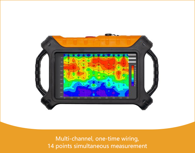
Smart and Flexible: Configurable 1–30 channels. Optional electromagnetic probes support TT mode measurement
R&D Since 1973
Stable Accurate

Free upgrading at the original price after purchasing within six months
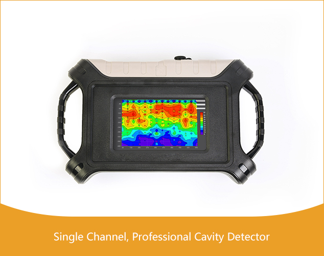
The 32-Channel Cavity Detector utilizes natural electromagnetic fields as the working source to investigate subsurface electrical structures. By measuring electromagnetic responses across a wide frequency range at the surface, it exploits the principle of varying skin depths to reveal resistivity differences at different depths, accurately locating and characterizing underground cavities, disturbances, karst voids, and more.
The ADMT Series 3D Imaging Cavity Detector is a leading professional-grade geophysical instrument for 3D imaging in archaeology and hazard assessment. It detects variations in subsurface resistivity caused by natural field strength changes to precisely determine the position, size, and depth of cavities, disturbed soil, and dissolution features. Widely used for leak detection in landfills, pre-construction void surveys, and disaster prevention, it is highly favored by professional archaeological teams and cultural heritage institutions.


Real-time
Imaging

Accurate
& Stable

Multi-screen
InterComm

Simple
Operation
MEET YOUR VARIOUS NEEDS

Archaeological Exploration

Hazard and Disaster Assessment
Archaeological Exploration: Ideal for locating hidden cellars, tombs, karst caves, and other features in archaeological surveys.
Hazard and Disaster Assessment: Essential for detecting underground voids, goafs (mined-out areas), subsidence cavities, and related geological hazards.
SIX ADVANTAGES
TO HELP YOU EXPLORE WORRY-FREE
High precision and strong anti-interference
 The core module of the instrument adopts an integrated package, with high precision and greatly enhanced anti-interference.
Equipped with a high-performance processor to run a variety of algorithms, the output is stable and accurate, ensuring the accuracy of the instrument in various environments.
Automatic drawing
 After the measurement is completed, a 2D, 3D color map and a variety of curve graphs will be generated.
Simple operation with 10.1-inch touch screen.
Learn to operate in 5 minutes.
Depth adjustable, intelligent and flexible
 Each product has a variety of adjustable depths, the number of channels can be set.
The two measurement modes of MN and TT can be switched, which is very intelligent and flexible.
Multi-screen data sharing
 Mobile phone, instrument, computer, remote terminal data sharing, only need to log in with the same account.
And support data sharing between multiple accounts.
Free upgrade, value-added purchase
 The instrument includes a full set of APP software to support online free upgrades.
And since the purchase of 6 months to maintain the value of other products.
Lifetime technical support
 Data processing and analysis, instrument maintenance online technical guidance and other services are all supported for life.
GOOD AT CORE AND BEAUTIFUL IN SHAPE

① Hi-Fi Signal Conditioning Amplifier Guaranteed signal accuracy
The analog circuit part of the front-end signal conditioning amplifier of the instrument adopts integrated packaging and shielding, which greatly enhances anti-interference, improves the signal input accuracy, and greatly improves the measurement accuracy of the instrument.
② High performance processor Run multiple algorithms
Adopt high-performance processor, run various algorithms, make the output stable and accurate, and ensure the measurement accuracy of the instrument
③ 10.1 inch touch screen operation
Real-time 2D/3D and curved images

① Switch ② Charge ③ Multi-function interface ④ 17-32 Channels ⑤ 1-16 Channels
Accessories

① Cable ② Electrode hammer ③ Electrodes
④ Wired connection EM sensor (optional)
It is suitable for any ground such as cement, rock, ground breaking, etc. It can be measured by a single person.
Product design, packaging, or accessories are subject to change due to ongoing improvements. For the most up-to-date information, please contact our service team.
MODELS AND TECHNICAL PARAMETERS
| Parameter | ADMT-60KG-32D |
|---|---|
| Max Depth (m) | ≤60 |
| Channel Input | 32 channels of simultaneous input with a standard electrode spacing of 2.5m, and optional spacings of 5m/7.5m/10m |
| Channel Options | 1-30 |
| Adjustable Depth | 5/10/20/40/60m |
| Scan Interval | 5-60 |
| Connection | Serial port, WiFi, Bluetooth 4.0, USB |
| Display | 10.1 -inch, IPS wide Angle, 178° visual touch screen |
| OS | Android 13 |
| CPU | RK3568 |
| GPU | Mali G52 |
| Features | Adjustable depth, customizable channel number, real-time 2D/3D imaging, removable battery |
| Meas. Mode | MN/TT |
| Freq. Range (hz) | 100-8K |
| Filtering | Preset frequency selection and intelligent frequency selection, analog + data filtering, 1-16 times stacking is optional |
| Discrim. | 0.01mV±2% |
| Acq. Time (s) | 40-3600 |
| Battery | 1000mA/H |
| Main Unit Weight | 2.2kg |
Trusted by Millions, CCTV Recommended

SERVING THE WORLD

PROFESSIONAL SERVICE TEAM

QUALIFICATION CERTIFICATE
Certificates and Awards: CE, ISO, China National High-tech Enterprise, China National Technical Invention Patent

R&D Since 1973
1973: Developed the domestic short-wire D75 electrical method
1977: Developed an aerial proton
magnetometer
1981: Developed domestic resistivity DW83 electrical method
1988: Developed a
multi-functional high-power electric method
2001: Developed the NEP series of natural electric field
geophysical probes
2005: Completed the "High-Density Electrical Method" project commissioned
by the Institute of Geology and Geophysics, Chinese Academy of Sciences
2011: Completed the
"Controllable Source Geodetic Electromagnetic Instrument (CSAMT)" project commissioned by the
Institute of Geology and Geophysics, Chinese Academy of Sciences
2013: Received the support of the
Innovation Fund of the Ministry of Science and Technology, and passed the Shanghai High-tech Achievement
Transformation Certification
2017: Developed mobile phone water-finding instrument and geophysical
instrument, supporting two-dimensional and three-dimensional automatic mapping of Android system
2018:
Independent research and development of 16-channel series products to solve the problem of natural electric
field source changes, simple, efficient and precise
2021: Water-finding instrument, geophysical
prospecting instrument, aerial geophysical prospecting, earthquake advanced prediction system, etc. will be
developed for cloud platform big data automatic analysis function
2022: The company was renamed
Shanghai Aidu Intelligent Detection Technology Co. Ltd, and expanded its business operations
2023:
Launched AI automatic analysis functionality, ushering geological exploration into a new era of
intelligence. Introduced speedy water exploration instruments, magnetotelluric instruments, and
high-precision three-component magnetometers
2024: Released an online monitoring system supporting ERT,
bipole electrical, magnetic, and other geophysical data acquisition, with integrated data fusion and
processing capabilities for geological hazard monitoring and prevention
2025: Released UAV magnetic
survey and unmanned boat electrical survey systems with automated acquisition, rapid imaging, cloud-based
inversion processing capabilities


Two-year
Warranty

Lifetime
After-sales

Expert
Support

Free
Upgrade